| VTS | ||
|---|---|---|
| Taichung Port VTS | 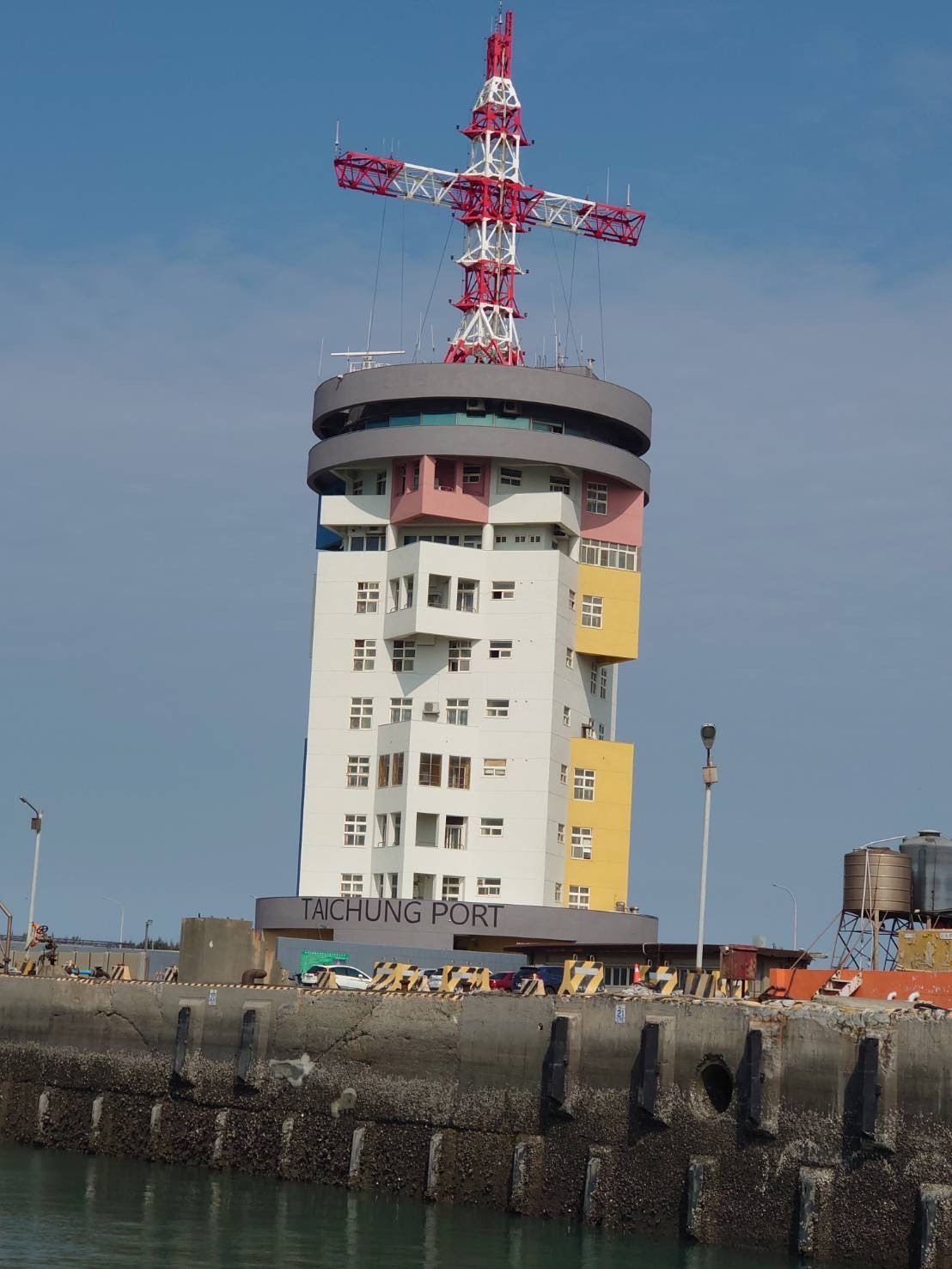 |
|
| Location | 24°17'23".7N 120°31'01".4E | |
| Height | 66.2 (meters) | |
| Configuration | Painted in checkered white and black on top of round roof | |
| Call Sign | Taichung Port VTS | |
| Working Frequencies(24 hours service) | 156.8MHz(CH.16) & 156.7MHz(CH.14) | |
| Taichung Harbor Lighthouse | ||
|---|---|---|
| Taichung Harbor Lighthouse | 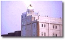 |
|
| Location | 24°17'16".8N 120°31'23".6E |
|
| Elevation of Light Above H.W. | 62(meters) | |
| Nominal Range | 26.8 (Nautical miles) | |
| Characteristic of Light | Fl.(3) 30s.69.5m26.8M | |
| North Breakwater Lighthouse (U) | |
|---|---|
| Location | 24°17'58".9N 120°29'11".46E |
| Elevation of Light Above H.W. | 21.9 (meters) |
| Nominal Range | 17.5 (Nautical miles) |
| Characteristic of Light | Fl.G.4s0.8sL & 3.2s21.9m17.5M Racon(M) |
| North Breakwater Racon | |
|---|---|
| Location | 24°17'58".9N 120°29'11".46E |
| Frequency | Sweep from 9300 MHz to 9500 MHz, 2900MHz to 3100 MHz |
| Frequency Sweep Time | 40 Seconds (time for each frequency sweep from 9300 MHz to 9500 MHz, 2900 MHz to 3100 MHz) |
| Output Power | 1 Watt. |
| Response Code | "M""(_ _) "Response when radar Beacon frequency sweeps through the interrogating radar frequency (every 40 seconds) |
| Nominal Range | 15 (Nautical miles) |
| Operating Time | 24 hours |
| South Breakwater Lighthouse (U) | |
|---|---|
| Location | 24°17'24".6N 120°30'02".2E |
| Elevation of Light Above H.W. | 21 (meters) |
| Nominal Range | 14 (Nautical miles) |
| Characteristic of Light | Fl.R.2s.21m14M Racon(F) |
| South Breakwater Radar Beacon | |
|---|---|
| Location | 24°17'24".6N 120°30'02".2E |
| Frequency | Sweep from 9300 MHz to 9500 MHz, 2900MHz to 3100 MHz |
| Frequency Sweep Time | 75 seconds (Time for each frequency sweep, from 9300 MHz to 9500 MHz, 2900 MHz to 3100 MHz) |
| Output Power | 1 Watt. |
| Response Code | "F" (. .- .) Respond when radar Beacon sweeps through the interrogating radar frequency. (every 75 seconds) |
| Nominal Range | 15 (Nautical miles) |
| Operating Time | 24 hours |
| Inner Breakwater North Lighthouse (U) | |
|---|---|
| Location | 24°17'18".7N 120°30'49".1E |
| Elevation of Light Above H.W. | 13.5 (meters) |
| Nominal Range | 12.3 (Nautical miles) |
| Characteristic of Light | Fl.G.3s.0.5sL & 2.5sD.13.5m12.3M |
| Inner Breakwater South Lighthouse (U) | |
|---|---|
| Location | 24°17'06".4N 120°30'42".8E |
| Elevation of Light Above H.W. | 13.6(meters) |
| Nominal Range | 10 (Nautical miles) |
| Characteristic of Light | Fl.R.3s.20.4m10M |
| Anchorage | |
|---|---|
| The water area to the west of South Breakwater,10 - 20meters deep, is appropriate for anchoring. It is inside the connecting lines of the following points: | 24°16'51".7N 120° 29'40".4E |
| 24°16'51".7N 120°28'59".4E | |
| 24°15'48".7N 120° 27'01".4E | |
| 24°15'48".7N 120° 26'12".4E | |
| 24°13'59".7N 120° 25'47".4E | |
| 24°13'59".7N 120° 27'59".4E | |
| Taichung Harbor Main Channel Direction Light | |
|---|---|
| Location | Forth Light 24° 16' 57".2N 120°31' 25".2E After Light 24° 16' 46".6N 120° 31' 51"E |
| Characteristics & Candle Power (Candlelas) | Forth Light Green fix, white after green, white fix, white alter red, red fix. Green color:50000cd White color:220000cd Red color:50000cd |
| Elevation (Meter) | Forth Light 51.0 After Light 76.0 |
| Range (Mile) | Forth Light 10-12 After Light 9.6 |
| Structure | Forth Light Square shape steel tower After Light Square shape steel tower |
| Remarks for Signals Sectors | Forth Light Two tower on one line:114°15'15" Green color:0.41-0.34o White alter green color:0.34-0.27o White color:0.27o White alte red color:0.27-0.34o Red color:0.34-0.41owhite color: "safe way" width 20 meterswhite alter green & white alter red color: "warning way" both width 25 metersgreen & red color: "danger way" both width |